The Country Catches Up to Callais
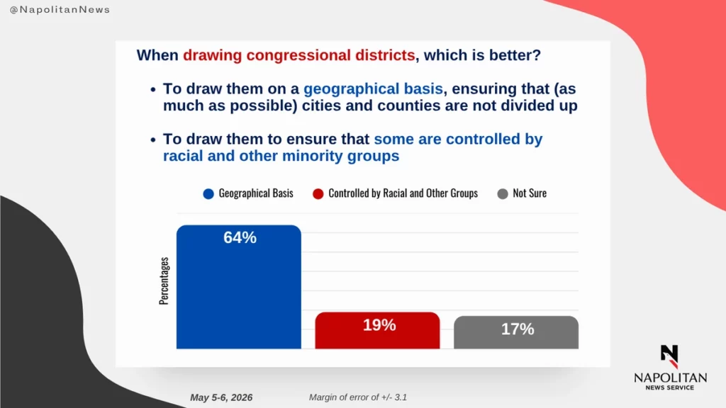
A new Napolitan survey finds voters reject race-based congressional maps by 45 to 33, with 64% favoring geographic lines. The Court was not the first to arrive at this conclusion.
The Supreme Court issued its ruling in Louisiana v. Callais (2026) on April 29. The American public, by every available measure, had already issued its own.
A new Napolitan News Service survey of 1,000 registered voters, conducted by Scott Rasmussen and RMG Research on May 5–6, 2026, finds that 33% of voters say states should be permitted to draw congressional maps to ensure a racial minority makes up a majority of voters within a district. Forty-five percent disagree. Asked the question in sharper form, whether districts ought to be drawn on a geographical basis or to ensure that some are controlled by racial and other minority groups, 64% chose geography. Nineteen percent chose group control.
The cross-pressures within the data are the news. Republicans oppose race-conscious maps 54% to 28%. Democrats split almost evenly: 39% in favor, 38% opposed. Black voters narrowly favor race-based maps at 49%; Hispanic voters at 52%. But on the geographic alternative the parties converge: 61% of Republicans and 68% of Democrats prefer that congressional lines follow communities rather than racial composition. Among voters with postgraduate degrees, the figure climbs to 79%. The credentialed cohort that has long supplied the intellectual case for race-conscious districting is, on the question itself, the cohort most opposed.
The premises that have animated forty years of post-Gingles jurisprudence do not survive contact with this data. Three quarters of voters say a black candidate can be elected to Congress in a majority-white district. The number among Republicans is 83%; among Democrats, 67%. Asked to imagine a Republican-leaning district with mostly white voters in which a black Republican faced a white Democrat, 45% say the black Republican would win, against 34% who pick the white Democrat. The Voting Rights Act of 1965 was written, and Thornburg v. Gingles (1986) was decided, against a country in which both questions would have been answered very differently. They are not answered that way now.
The political ground is shifting to match. Of the 148 racially drawn districts catalogued by Ballotpedia, 122 are held by Democrats, and the Justice Department, through Civil Rights Assistant Attorney General Harmeet Dhillon, has confirmed it will enforce Callais in every state where such maps still exist. California’s Proposition 50 sits in legal limbo, its author having publicly described one of its districts as a “VRA district,” a label that under the new precedent invites a successful legal challenge.
What is striking in the Napolitan numbers is how little turns on partisan calculation. By majorities running across party, region, and education, the country has settled on a position. Districts should follow communities. The same map should not be drawn twice for two purposes. Race ought not to be the principal criterion for assembling a constituency.
The Court has now ruled the same way. The next question is whether the political class, on either side, intends to honor the verdict the country had already reached.